Adelaide’s sandy coastal environment
There are some books that help better understanding tidal action, coastal sand movements and how dunal systems work. Once understanding these processes, Adelaide’s coastal sand movement becomes clearer. As a start to reading, the “Perspectives of the Earth” (Clark & Cook, 1983) describes weathering and erosion, different processes, dunal systems and their functions, geomorphology and more. The best person to talk to would be an experienced geomorphologist who specializes in coastal geomorphology or university professor of this.
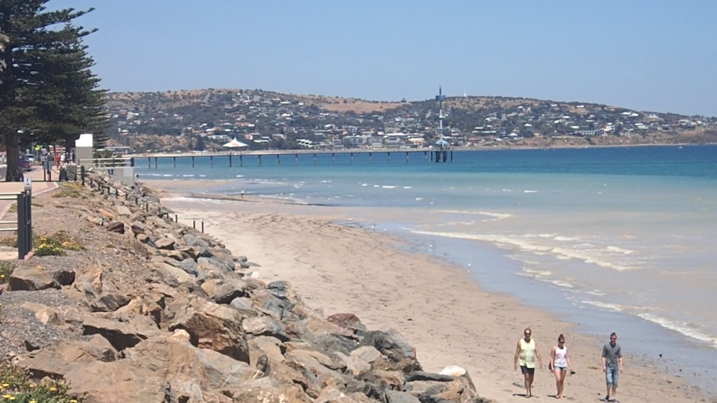
The Adelaide coastline has a predominantly northerly wave action and current, transporting beach sediments northward. The southern end of the Adelaide plains (i.e. the city/inner metro plains, flanked to the south by the Adelaide hills (which are fault scarps)) is bordered by the extensive coastal reef system starting around Kingston Park, or Marino which leads south. Over winter and storm events, wave action smash into the coast and, over millions of years, this action increasingly wears down rocks to finally becoming sands and silts. The round rocks seen on beaches (e.g. Marino Rocks, Hallett Cove, Aldinga South) is indicative of this process, and the size of the transported rocks and their degree of rounding indicates the strength and extent of the weathering and erosional processes at work. Sands originating further south (e.g. Hallett Cove, Moana, Port Noarlunga) also will be transported over and along the southern coastal reefs, with sea plants acting to trap some sand also. The sand will continually become finer as it is ground during transportation. Shell grit also is an important component of beach sands.
With the Adelaide longshore drift system process (a.k.a littoral drift) sands appearing at Seacliff, adjacent to the southern coastal cliff/reef system (Marino), are over time transported by wave action further north and eventually reach North Haven (the Outer Harbor southern causeway acts as a barrier, to an extent). The deposition of sands at North Haven has been problematic for some activities. This action of longshore drift also acts as a further weathering process with particles of sands becoming finer. Finer sand particles are lighter and are more easily transported by wave, current and wind actions. Finer sand particles progressively become silt and clay sized particles and, with erosion, may be deposited further out to sea by currents or wind. During storm (higher energy) events, these offshore sands may be transported and deposited elsewhere. It is worth noting that the prevailing wind direction is also to the North.
Another factor leading to the disappearance of sand along local beaches is the lack of a functioning dune system. This is due to actual development of Adelaide as a city and building on top of the existing dune system. As evidence, looking at the lay of the land, the topography shows the coastal dunal system has been covered by housing and roads. This can also be seen when houses are demolished, and excavations expose the sand strata. Dune systems provide the mechanism of retaining sand, a sand bank, which is normally depleted during winter storms and replenished during summer months. Diagrams and explanations of this seasonal cycle of sand dune systems is commonly further explained in books.
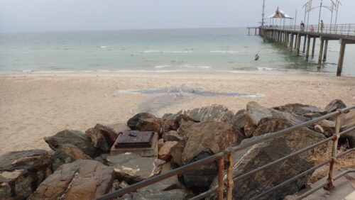
Other lesser factors are many. The rock walls typically built to protect shorelines from storm damage replace the much larger volume dune systems and land masses for waves to weather and erode. These rock walls typically built of hard rock resistant to weathering offer no substitute of sand replenishment to beaches.
Large bags of sand lined perpendicular to the shore leading into the sea have some benefit and have slowed erosion of sand. They do not extend greatly past the shoreline into the water under the low tide mark.
Hauling of sand from the northern areas of beach to deposit at various sites to the south has been replaced by an underground sand pumping system. The pumping of sand has occurred generally before the summer beach season starts to top up the beaches with sand. Large pumping stations (installed mid-2000’s?) indicate some of the outlets, while others appear as what could be a storm water outlet (e.g. Brighton Jetty). There are many outlets along the coast between Glenelg and Seacliff. When sand is pumped it leaves outlets as a slurry with piles of sand showing where the pumped sand is. Outlets pump out sand individually of each other at different times. The finer particles of pumped sand hang in the water over days and weeks. If the weather becomes rougher, the murky water persists longer typically. If the weather picks up (i.e. seas become rougher) after pumping, the turbidity is worse also, close to shore. Pumping sand is to replenish the beaches of lost sand; pumping sand also diminishes grain size through its very action, resulting in finer size particles that are suspended in a shore-based plume, increasing the turbidity of water locally. As it disperses and pumping continues in the area this plume extends further out to sea, as well as along the coast. Initial pumping the plume is observed as persisting between 40 to 60 metres, and then moves further out, dispersing as it does. The more times sand is pumped, the smaller the same grain will become. The more times that sand is pumped, the larger the volume of sand is pumped.
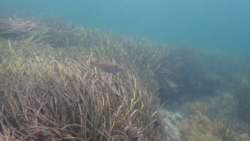
The disappearing marine vegetation also contributes to losing sand, as observed areas of predominantly marine vegetation acts to trap sand.
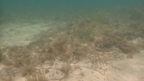
From the Adelaide shoreline, the offshore sands (recently once seagrass beds) at Somerton have been observed as missing, scoured down to the friable mud and clay bottoms previously covered by sand. Other area with greater topographic relief and better vegetation show less evidence of this. Plant structures act to trap and deposit particles of sand and retain this sand, while crevices in rock and reef act somewhat as buffers against current energy and provide deposition sites for particles. Plants also act to protect each other, buffering energy. As plant life decreases, the remaining plants are observed more exposed to the full energy of currents.

Oct/Nov 2014, Sand pumping October 2014, showing active pumping from the station some 100m down the beach, and resulting plume along coastline, which stubbornly remains in the water but spreads out deeper over time. Brighton Jetty in background, sand pumping often blamed for no fish.
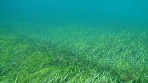
Seagrass in Adelaide coastal regions, 2023
Observing the seagrass at Brighton and Somerton over some years, the areas are viewed from shore on clear days have receded dramatically in approximately the last ten years – 2010-2023, with latter years worsening. This coincides with the starting of the desal plant (useful data not available) and the sharp rise of increased runoff due to high density urban infill, with also increased spread of urbanization.
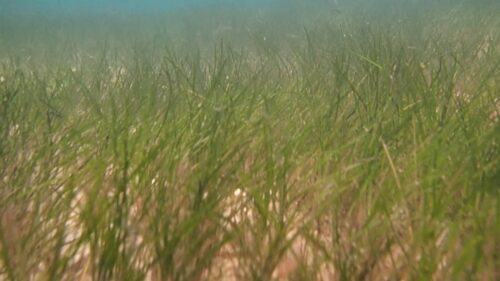
Seagrass growth is cyclic, with masses of dead seagrass typically washing up on metropolitan beaches each winter, and the subsequent regrowth in previous time more or less balanced.
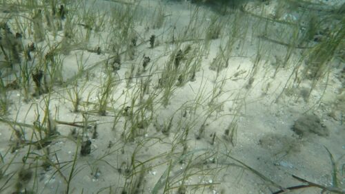
From 2000, and before seagrass is typically growing out to sea (<200m), it could be described as wide spread and continuous with pockets of sandy areas. The areas of seagrasses closer to shore that were small or sparse disappeared faster than the thicker pockets in similar areas.
Offshore the seagrass beds were observed as raised beds, often around by, or less than, 1 metre. These bed walls then rapidly crumble away when the seagrass has been removed. The associated shellfish seem to die off following seagrass die off, but often the areas with no shellfish present, seagrass disappears sooner than the same areas with shellfish present.
The southern areas around Seacliff has appeared to be not as affected as areas moving northward to Glenelg. Generally the situation progressively gets overall worse moving north.
The concerns of Adelaide’s high density urbanization, with much greater run off entering the storm water drains, is widely recognized as cause for concern regarding the health of the local marine environment and surrounding Gulf region. In the Adelaide plains metro area, there are, and continue to be, measures taken to try to limit pollution of runoff inevitably entering local marine waters.
Increasingly systems, mostly inland, are put in place to improve the water quality of runoff entering the sea. Largely, there is no filtration through any coastal based wetlands, with maybe a few exceptions. Adelaide’s urban run-off drainage system, to a large extent, leads uncontrolled directly into the ocean, despite the increasing and varied measures being used. Apart from the few run-off areas leading past monitored stations for water quality, such as the Patawalonga or Port River, a great deal of run-off is not tested or monitored for quality. Regardless, it all washes out into the Gulf around Adelaide. A good test of water quality is considering if you would drink the water that is entering local waters at a particular site.
February 2022, The start of a storm water runoff following a summer storm just before it enters water at Brighton Jetty after a dry period. Note the condition of the runoff water exiting the stormwater outlet compared to the relative clarity of the sea in the background. Often signs are erected warning swimmers not to swim in the dirty water after storms. This is a typical example of the many outlets along the Adelaide coastline.
The increasingly poor state of health of the marine environment and lack of understanding of the factors contributing to this illustrate the increasing need to better understand the changing conditions. A system of monitoring stations recording the changes in temperature, salinity, dissolved oxygen, nitrates and other pollutants, with control sites located further away, would help to identify problems. When any environment undergoes a change, everything in that environment needs to be able to adapt with that change. When changes result in the removal of something, this inevitably means other things need to be able to adapt to that removal. What can follow is a chain reaction of system collapse. In the case of the removal of seagrass, the consequences are extremely serious when considering its importance to the marine ecosystem.
December 2011, Brighton. Seagrass out from the jetty in which bare patches of sand have become increasingly bigger over time.
January 2021, Somerton South, typical seagrass die off pattern, showing outline of previous plant growth fringe.

Jan 2023, Somerton. Outer fringe of remnant seemingly healthy seagrass in foreground of area previously covered extensively (almost exclusively) by seagrass, in background is progressively dying seagrass area covered by algal growth, a typical pattern of dieback observed in recent years. There is some cyclic evidence with an overall degradation of the areas observed prior to 2023.
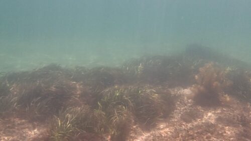
Areas adjacent to rocky reef areas the sand is typically coarser with pronounced coarse shell grit compared with other areas. The areas adjacent to rocky reef has an observed lower rate of denudation compared to the wider area but is still happening. Generally, seagrass areas often also contain wide areas of clean coarse grained sand bowls, which widen as dieback progresses. After storm events, this coarser sand may be removed, and (without coarse replacement sands) further replaced by finer sediments with lower energy transportation weathering events (i.e. Fringes of denuded areas often show patches of remnant seagrass with inner areas thinning quicker. Sand is progressively removed with seagrass dying off as sands become more exposed to tidal actions without the buffer of seagrass which had previously acted to trap those sands. Sand typically captured by seagrass was coarse in size compared to the much finer beach sands seen today (being currently introduced to the beach environments by artificial means i.e. pumping/carting). Natural means, for example, are by weathering such as wave action on beaches, reefs, exposed coastlines, and river discharge with sediments also.
* (when describing cross sections of soil, it is the second layer down under the top soil.)
Jan 2023, Somerton. New growth of seagrass(?) in area previously denuded. Existing established seagrass patches nearby. Originally was thick established seagrass here.
Feb 2023, Second Valley. For comparison of seagrass areas away from Adelaide. Note the banking typical on edges of seagrass beds and algal growth present.

April 2022, Seacliff. This alga, when thick, affects the seagrass. The seagrass without this alga appear much healthier. This area seems to have fared much better than Somerton.

November 2021, Somerton South. This alga covers the seagrass progressively, different in appearance to the algal balls pictured above. The edges of the area had areas of seagrass which appeared healthy in places. Where the algae had covered seagrass over time, seagrass was dying or no longer present. Black algal tufts remain for some time in similar location where seagrass has been removed.
January 2018. Some seagrass die-off, leaving clumps of seagrass dispersed in what was previously a solid seagrass bed. Note the edge of the seagrass bed is often last to die off.
April 2017, Somerton. New seagrass growth.

January 2016, Marino. Algal balls as at Seacliff. Note algal growth is predominantly on dying or dead seagrass strands.
By observing the differences of local Adelaide coastline waters compared with areas away from here, the water is, in general, consistently clearer with a visibly healthier marine ecosystem. Talking to older observers, the shifting baseline of Adelaide’s waters has been ongoing (in decline), being obviously significantly deteriorated over time, no matter who is asked. Seagrass is most recently under focus and the changes introduced in recent times, logically, by the rate of denudation, have done nothing to improve this, and all indications point to escalating the problem. Although arguing “prove it” is a common response, it is easy enough for most to understand any changes to an ecosystem will inevitably lead to changes affecting life within the ecosystem, that unless introduced changes are made to specifically target enhancing a lifeform, it is most unlikely any changes will co-incidentally be of benefit to that environment.
Some differences to the Adelaide region compared with areas further away.
- Population, increasing population with increasing housing density with urban spread extending progressively farther along coastal areas, leading to dramatically more runoff.
- Runoff, man-made drains, natural waterways converted to concrete lined drains, road runoff, comparatively decreased ground water seepage, pollution of aquifers and waterways.
- Pollution, air pollution, pollution in general.
- Pollutants such as hydrocarbons, various liquids, detergents, heavy metals, plastics.
- Local desalination plant to the south at Lonsdale with lack of water quality data available.
- People and activity near and around the water (increasing with population growth).
- Industry.
- Sewage treatment.
- Lack of, and loss of, a natural coastal fringe.