I think that I first became fascinated with jetties when I first started scuba diving in January 1978 after visiting Port Hughes jetty. I did my first sea dive at Port Noarlunga jetty in February 1978. Although I had visited several piers whilst I was in England, it was mainly through diving in South Australia that my love of jetties grew.
Diving led me to an interest in the history of local shipwrecks and jetties. My interest increased when I first became our Society’s newsletter editor in April 1981. I may have written articles about jetties any time after that, but the first one that comes to mind is one that I wrote about Port Noarlunga and its jetty. The article titled simply “Port Noarlunga” was published in our July 1984 newsletter (No.86). I also remember writing little pieces about the storm that destroyed the old Glenelg jetty in 1948. These led to an article titled “The Glenelg Jetty” which was published in two parts in our June & July 2002 newsletters (Nos.289 & 290).
It may have been sometime back then that I had started to compile a card system for details regarding dive site locations, jetties and other SA place names of interest. I would use the cards from my system for newsletter articles. As my card system grew, I dreamed of writing a book about SA jetties. It was only my busyness with our Society, newsletters and journals that prevented me from getting on with my jetty book project.
I managed to make a start writing about jetties, however, by about 2005. My dream about writing a book about jetties came crashing down that year though when Neville Collins published his book “The Jetties of South Australia – Past and Present”. Neville had succeeded where I had failed. His book may well have spurred me on in some way though. It had much of the information that I required for my work.
Neville came along to one of our Society meetings to talk about his book on jetties about that time. I even attended another talk on the same topic by him at the Semaphore Library.
My work writing about jetties may have taken a slight turn when it became more focused on jetties that had disappeared. My article titled “Some of SA’s Long Lost Jetties” was eventually published in three parts in our February, March & April 2006 newsletters (Nos.329-331).
(Somehow, the title became sub-titled “SA’s First Jetty” due to an editorial error.)
The article went from being about jetties that had disappeared, to being about jetties that had been rebuilt or replaced, to being about jetties that had simply been shortened because of storms. It concluded with discussing the slipway rail tracks close to the Port Hughes jetty. There was, however, a list of references at the end of the article. This list indicated that I had written about the Semaphore jetty in both 1992 & 1993.
In 2011, I was writing about the Second Valley jetty. An article titled “The Steps at Second Valley Jetty” was published in our August 2011 newsletter (No.384). Several articles about Second Valley and the jetty there appeared in our 2011 Journal (No.21).
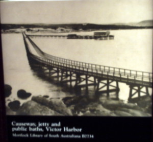
The August 2011 newsletter also included my article titled “My Recent Visit to the SA Maritime Museum”. The newsletter included this old photo of the Granite Island causeway: –
I had taken a photo of the photograph at the Maritime Museum during my visit there. According to my article, “It was taken from the island, looking back towards the mainland. It shows the old Victoria Pier (with public baths) in the background.”
I made a start writing another article titled “Three Jetties Built at Granite Island”, but I never finished it. It went like this: –
“Three jetties have been built at Granite Island at Victor Harbor on the Fleurieu Peninsula, as I reported in our November 1985 Newsletter (No.101). I was, however, a little confused when I said that the island’s first jetty was built in 1862 and that the causeway from the mainland to the island was completed in 1875. The causeway started off as the first jetty. It was built between 1862 and 1864. A pier was built at the end of this first jetty. It was named the Victoria Pier after Queen Victoria and it was opened on 4th August 1864, following the opening of the extension of the railway from Port Elliot to Victor Harbor on the same day. A large stone shed was erected at the end of the jetty to hold goods awaiting shipment. A tramway was also opened along the first jetty that same year. This tramway was heavily worked and the goods shed apparently bulged with wool bales awaiting shipment. People resumed their call for the first jetty to be extended to Granite Island so that ships could dock in deeper waters. The first jetty (causeway) was extended to Granite Island in 1875 and another jetty was built on the island. The causeway extension and new jetty cost £8950. The new jetty (described as “a timber-piled wharf”) was called the Working Jetty or Shipping Jetty. In 1878 work started on the Screwpile Jetty and the nearby breakwater on the island. Both the jetty and the breakwater were finished in 1882 at a cost of £122,171. So what became of the Victoria Pier and the Working (or Shipping) Jetty? I have only been able to find out that one of them was demolished in 1957. This was the year that the causeway had to be rebuilt and may give a clue as to which jetty was demolished then. The Screwpile Jetty was also reconditioned that same year (1957).”
In Part 2 of my article “Some Of SA’s Long Lost Jetties” I wrote: –
The Old Victoria Pier at Victor Harbor
The first part of the causeway to Granite Island at Victor Harbor was built between 1862 and 1864. It was Victor’s first jetty. A pier was built at the end of this jetty. It was named the Victoria Pier after Queen Victoria and it was opened on 4th August 1864, following the opening of the extension of the railway from Port Elliot to Victor Harbor on the same day.
The Old Victor Harbor Swimming Baths
Swimming baths were constructed on either side of the jetty (causeway) because men and women had to bathe separately. A deeper swimming area was then built between the jetty and its spur (the Victoria Pier) in 1899. A larger area had to be made for swimming by 1905. The baths had a shark-proof fence built around them. The baths, however, fell into such a bad state of disrepair that they were not being used and were eventually demolished in 1955.
The Old Granite Island Jetty
Victor Harbor’s first jetty was extended to Granite Island in 1875 (to become the causeway) and another jetty was built on the island. The new jetty (described as “a timber-piled wharf”) was called the Working Jetty or Shipping Jetty. It ran in an easterly direction in continuation of the roadway (on the island) from the end of the causeway.
Site of the Working Jetty on Granite Island in 2005
(Taken by Steve Reynolds)
In 1878 work started on the Screwpile Jetty and the nearby breakwater on the island. Both the jetty and the breakwater were finished in 1882. So what became of the Victoria Pier and the Working (or Shipping) Jetty? I have only been able to find out that one of them was demolished in 1957. This was the year that the causeway had to be rebuilt and may give a clue as to which jetty was demolished then. The Screwpile Jetty was also reconditioned that same year (1957).”
“The Jetties of South Australia – Past and Present” by Neville Collins included an old photo of the Working Jetty on Granite Island. I also found this photo at the Maritime Museum of the Working Jetty: –
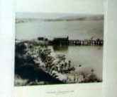
Photo at the Maritime Museum of the Working Jetty
My friend (& dive buddy) Allan Horsfall has now provided me with several old postcards showing the old jetty. These are reproduced below: –
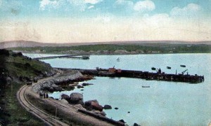
The Working Jetty (with Victoria Pier in background)
(Postcard courtesy of Allan Horsfall)
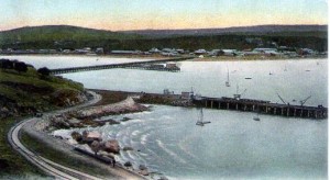
The reduced Working Jetty (with Victoria Pier in background)
(Postcard courtesy of Allan Horsfall. This card was produced prior to March 1907.)
The two postcard images above show a full Working Jetty. The following two images, however, show a much reduced Working Jetty, with what appears to be a slipway attached to the jetty: –
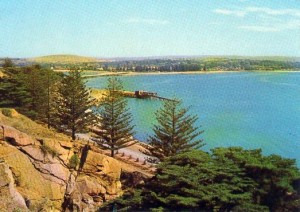
The reduced Working Jetty (with no ‘pier’ in background)
(Postcard courtesy of Allan Horsfall)
The Working Jetty (with no ‘pier’ in background)
(Postcard courtesy of Allan Horsfall. This card was produced prior to August 1967)
Many thanks go to Allan Horsfall for providing these postcards which show how the Working Jetty must have changed over a number of years.
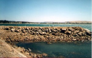
I took a series of photos showing the remains of the Working Jetty during a visit to Granite Island in 2005. Here is one of them: –
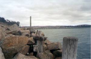
Some remains of the Working Jetty in 2005
(Taken by Steve Reynolds)
To finish off, here is a list that I prepared back on 1st April (true!) 2006: –
SA JETTIES BUILT DURING THE 1800s OR EARLY 1900s
By Steve Reynolds
As mentioned in Part 1 of my article titled “Some of SA’s Long Lost Jetties” (MLSSA Newsletter February 2006, No.329) several jetties were built at Reeves Point on Kangaroo Island from 1836. A stone pier was built at Marino about 1840. Many jetties were subsequently built and are listed below in chronological order. The list was reformatted with assistance from Dan Monceaux in 2017.
| Jetty | Region | Waters | Commenced | Completed |
| Reeves Point | Kangaroo Island | Investigator Strait | 1836 | |
| Marino | Adelaide plains | Gulf St. Vincent | 1840 (circa) | |
| Southend | South-east | Southern Ocean | 1850s | |
| Port Augusta | Mid-north | Upper Spencer Gulf | 1850s | |
| Port Elliot | Fleurieu Peninsula | Encounter Bay | 1852 | |
| Port Willunga | Fleurieu Peninsula | Gulf St. Vincent | 1853 | |
| Normanville | Fleurieu Peninsula | Gulf St. Vincent | 1853 | |
| Port Willunga | Fleurieu Peninsula | Gulf St. Vincent | 1853 | |
| Port Noarlunga | Fleurieu Peninsula | Gulf St. Vincent | 1855 | |
| Second Valley | Fleurieu Peninsula | Gulf St. Vincent | 1855 | |
| Robe | South-east | Southern Ocean | 1855 | |
| Bluff, Victor Harbor | Fleurieu Peninsula | Encounter Bay | 1856 | |
| Milang | 1856 | |||
| Glenelg | Adelaide plains | Gulf St. Vincent | 1857 | 1859 |
| Port Lincoln town jetty | Eyre Peninsula | Spencer Gulf | 1857 | |
| Harveys Return | Kangaroo Island | Investigator Strait | 1858 | |
| Kingston SE | South-east | 1858 | 1863 | |
| Semaphore | Lefevre Peninsula | Gulf St. Vincent | 1859 | |
| Myponga Beach | Fleurieu Peninsula | Gulf St. Vincent | 1860 | |
| Port MacDonnell | South-east | Southern Ocean | 1861 | |
| Wallaroo | Yorke Peninsula | Spencer Gulf | 1861 | 1862 |
| Port Clinton | Yorke Peninsula | 1863 | ||
| Causeway & Victoria Pier, Victor Harbor | Fleurieu Peninsula | Encounter Bay | 1864 | |
| Rapid Bay | Fleurieu Peninsula | Gulf St. Vincent | 1867 | |
| Meningie | 1867 | |||
| Port Pirie | Mid-north | Upper Spencer Gulf | 1868 | |
| Mulgundawa(r) | 1869 | |||
| Moonta Bay | Yorke Peninsula | Spencer Gulf | 1870 | 1872 |
| Edithburgh | Yorke Peninsula | Gulf St. Vincent | 1872 | 1873 |
| Warrengie | 1873 | |||
| Port Broughton | Yorke Peninsula | Spencer Gulf | 1873 | |
| Tumby Bay | Eyre Peninsula | Spencer Gulf | 1873 | 1874 |
| Working Jetty, Granite Island | Fleurieu Peninsula | Encounter Bay | 1875 | |
| Ardrossan | Yorke Peninsula | Gulf St. Vincent | 1876 | 1877 |
| Point Turton | Yorke Peninsula | 1876 | 1877 | |
| Point McLeahy | 1877 | |||
| Port Vincent | Yorke Peninsula | 1877 | ||
| Stansbury | Yorke Peninsula | Gulf St. Vincent | 1877 | |
| Port Minlacowie | Yorke Peninsula | 1877 | ||
| Narrung | 1877 | |||
| Port Victoria | Yorke Peninsula | Spencer Gulf | 1877 | 1878 |
| Grange | Adelaide plains | Gulf St. Vincent | 1878 | |
| Althorpe Island | – | Investigator Strait | 1878 | |
| Port Rickaby | Yorke Peninsula | 1879 | ||
| Louth Bay | Eyre Peninsula | Spencer Gulf | 1879 | |
| Beachport | South-east | Southern Ocean | 1878 | 1882 |
| Penguin Island | – | Southern Ocean | 1880 | |
| Venus Bay | Eyre Peninsula | Great Australian Bight | 1880 | |
| Mount Dutton Bay | Eyre Peninsula | 1880 | ||
| Port Germein | Mid-north | Upper Spencer Gulf | 1880 | 1881 |
| Balgowan | Yorke Peninsula | 1881 | ||
| Elliston | Eyre Peninsula | Great Australian Bight | 1881 | |
| Cowell | Eyre Peninsula | Spencer Gulf | 1881 | |
| Port Moorowie | Yorke Peninsula | Investigator Strait | 1881 | |
| Lipson Cove (near Tumby Bay) | Eyre Peninsula | Spencer Gulf | 1882 | |
| Wool Bay | Yorke Peninsula | Gulf St. Vincent | 1882 | |
| Arno Bay | Eyre Peninsula | Spencer Gulf | 1882 | |
| Largs Bay | Lefevre Peninsula | Gulf St. Vincent | 1882 | |
| Henley Beach | Adelaide plains | Gulf St. Vincent | 1883 | |
| Screwpile Jetty, Granite Island | Fleurieu Peninsula | Encounter Bay | 1882 | |
| Brighton | Adelaide plains | Gulf St. Vincent | 1885 | 1886 |
| Beare Point, Kingscote | Kangaroo Island | Investigator Strait | 1886 | |
| Marion Bay | Yorke Peninsula | 1889 | ||
| Streaky Bay | Eyre Peninsula | Great Australian Bight | 1892 | |
| Fowlers Bay | Eyre Peninsula | Great Australian Bight | 1894 | 1896 |
| Port Julia | Yorke Peninsula | Gulf St. Vincent | 1895 | |
| Port Davis | Mid-north | Upper Spencer Gulf | 1899 | |
| Muston | Kangaroo Island | Pelican Lagoon | 1900s (early) | |
| Whyalla | Eyre Peninsula | Upper Spencer Gulf | 1901 | |
| South Neptune Island | – | Spencer Gulf | 1901 | 1902 |
| Penneshaw | Kangaroo Island | Backstairs passage | 1902 | |
| Ceduna | Far West | Great Australian Bight | 1902 | 1903 |
| Sceale Bay | Eyre Peninsula | Great Australian Bight | 1905 | |
| North Shields | Eyre Peninsula | 1906 | ||
| Cape du Couedic | Kangaroo Island | 1907 | ||
| American River | Kangaroo Island | Pelican Lagoon | 1908 | |
| Marum Island | – | 1909 (circa) | ||
| Denial Bay | 1909 | |||
| Port Lehunte | 1909 | 1911 | ||
| Kingscote | Kangaroo Island | Investigator Strait | 1910 | |
| Laura Bay | 1911 | |||
| Vivonne Bay | Kangaroo Island | Southern Ocean | 1911 | |
| Port Neill | Eyre Peninsula | Spencer Gulf | 1911 | 1912 |
| Smoky Bay | Far West | Great Australian Bight | 1911 | 1912 |
| Haslam | Eyre Peninsula | Great Australian Bight | 1911 | 1912 |
| Port Hughes | Yorke Peninsula | Spencer Gulf | 1911 | 1913 |
| Port Kenny | Eyre Peninsula | Great Australian Bight | 1912 | 1913 |
| Stenhouse Bay | Yorke Peninsula | 1913 | ||
| Port Gibbon | Eyre Peninsula | Spencer Gulf | 1915 | |
| Emu Bay | Kangaroo Island | Investigator Strait | 1918 | |
| Klein Point | Yorke Peninsula | 1918 | ||
| Thevenard | Far West | Great Australian Bight | 1920 | |
| Antechamber Bay | Kangaroo Island | Southern Ocean | 1922 | 1923 |
| Loveday Bay | 1923 | |||
| Coobowie | Yorke Peninsula | Gulf St. Vincent | 1925 | |
| Cape Jervis | Fleurieu Peninsula | Backstairs passage | 1938 |
The above list is intended only as a guide. Much more research is needed to discover the details. Many of the above mentioned sites had more than one jetty built there.
Photographs of the old jetties built at Granite Island could previously be viewed at the kiosk on the island. The Largs Bay kiosk still displays old photos of the Largs Bay jetty. Many old jetty photos can be found at Sea Witch Images in Lipson Street at Port Adelaide.
When was the Minlacowie jetty demolished? Some websites (and I understand info on the cairn on the beach) suggest 1971, but I’m sure it was there for longer.
We would be interested to hear whether your suggestion is correct. According to “The Jetties of South Australia”, it was in 1971 that the Harbors Board “decided to completely remove the jetty” but that’s not indicative of the actual time of the demolishing of it. Portions of the demolished jetty were said to have been used for the restoration of the Port Rickaby jetty, which occurred in the early 70s.
Do you have information on who built the jetties? I believe my ancestor John Tate may have been responsible for many of them, including Kangaroo Island, as that is where he met his wife.
Thanks Julie, there may be some info re some of the jetties. Neville Collins has written a very good book that has been revised.
That would be a good starting point. Otherwise, we may be able to check on particular jetties of interest. Do you suggest starting with KI?
Hi Julie
We have looked at Neville Collins’ book “The Jetties of South Australia – Past and Present”.
A quick scan reveals that a J.TAIT was one of the builders of the Penneshaw jetty on KI. The book says that the jetty was built by J.Tait and T.Durham.
We would need to scan the whole book to find any reference to a John Tate/J.Tait.
The last number I had for Neville Skinner was 0411 295 766.
Cheers
Steve
Hi, I’m interested in the Mulgundawa jetty which has a (r) next to it. I guess it was built, as my ancestor was the person who was contracted to overseer the works – Samuel Carvosso. Is this jetty still there? I’ve never seen signs to it and we do go occasionally on the road from Wellington to Strathalbyn.
Hi Miriam
Mulgundawa/Mulgundawar jetty was demolished over 109 years ago (prior 1913).
Cheers
Steve
Hi Steve – many thanks for your reply. Much appreciated and will add a little more to my gt-gt-grandfather’s story!!
Can you help me find more details about the jetty which was built in Coobowie Yorke Peninsula, it was made of stone, and ketches sailed over from Adelaide to Coobowie delivering goods and uploading farming products-salt, wool etc. Ib am looking for photographs of the jetty, when it was new, and also when it was in use.
Hi Audrey, Neville Collins’s book The Jetties of SA says the causeway was 222.5m long and the jetty was 29m long.. it was demolished in 1953. Upto 2005 at least, two poles joined by a single timber brace could still be seen. That was the end of the stone causeway.you may be able to contact N Collins on 83899154. You could also try Valerie Roe from Yorketown History Society on 88521778 or po box 197 Yorketown. I can send you two paras from A Story of Coobowie, Edithburgh and District if you like. Cheers Steve