The large anchor at Port Noarlunga reef seems to have come from the Duilius
by Steve Reynolds
In his “South Aussie Snippets” column in the August 2018 issue of Dive Log magazine, Christopher Deane suggested that the large anchor at Port Noarlunga reef had come from the shipwreck of the Duilius (pronounced Du-elius).
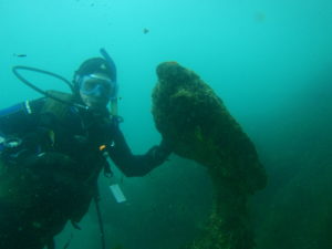
Just what is known about the Duilius and the big anchor? The anchor was placed in its current position by members of the Sea Wolves Dive Club after being dislodged from its earlier position by a storm.
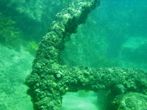
It had been placed in its earlier position by some divers (from the Scuba Divers Club of SA?) on Sunday 22nd January 1978. They moved the anchor from where it had been buried in sand to a rocky area where it would be seen more by divers.
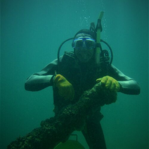
Re the anchor being placed by some divers from the Scuba Divers Club of SA on Sunday 22nd January 1978, it was reported in a 1978 issue of Skindiving in Australia that “the Scuba Divers Club, and Igo & Jill Oak from the Underwater Photographic Society moved the anchor from where it lay nearly buried in sand on the northern end of Port Noarlunga Reef to a rocky area about 130 metres south of the jetty.It is hoped that all divers and snorkellers will receive greater enjoyment from the anchor in this position. Igo Oak also filmed the operation which involved one boat and four 44 gallon drums.”
Christopher Deane has suggested that the anchor was first moved from its original position by the reef in the 1960s and he has this photographic evidence of that move: –
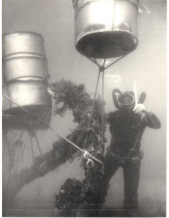
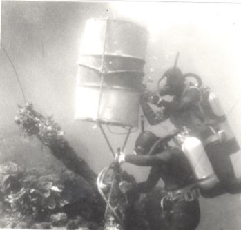
(Both photos courtesy of Christopher Deane & Con Penglis)
(After reading the above comments in the 1978 issue of Skindiving in Australia about how the anchor had been placed by some divers on Sunday 22nd January 1978, and that Igo Oak filmed the operation, which involved four 44 gallon drums.” I was thinking that those two B&W photos showing the anchor being moved were possibly taken in 1978 rather than the 1960s. Those twin-hose regulators, however, suggest otherwise.)
At some stage during this century, the anchor shifted from its 1978 position in a storm and sank in sand once more. A group of divers from the Sea Wolves re-positioned it on a large flat rock to keep it above the sand.
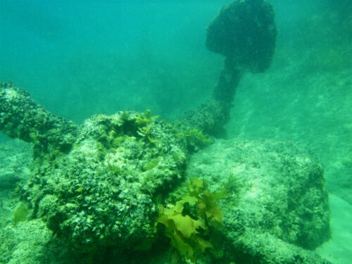
To the best of my knowledge, nobody seemed to know the original source of the anchor, other than that it had been somewhere in the bay at Port Noarlunga. Some people thought that it may have come from either the David Witton or the Tigress.
Christopher Deane has always maintained an interest in the topic. He suggested in the August 2018 issue of Dive Log that the anchor had come from the Duilius when he stated, “I guess that there is good circumstantial evidence from the information on the 1853 plan* to confirm the name of the wrecked vessel from which the anchor came is most likely the barque Duilius”.
* The 1853 plan referred to was a plan for a new mooring using a salvaged anchor reported to be from a wreck in Guichen Bay called the Dauntless – see below. The only problem is that no such vessel is known about. The only vessel that ‘fits the bill’ (and sounds similar) is the Duilius.
The Duilius was wrecked at the same site (Guichen Bay) in April that same year (1853). The ship’s anchor had been salvaged and put up for sale in June that year.
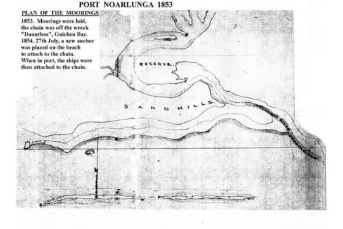
A new plan for moorings, however, was drawn up in 1857. Here is the 1857 new mooring indicating two mooring chains laid out from the north reef to assist vessels in a westerly gale: –
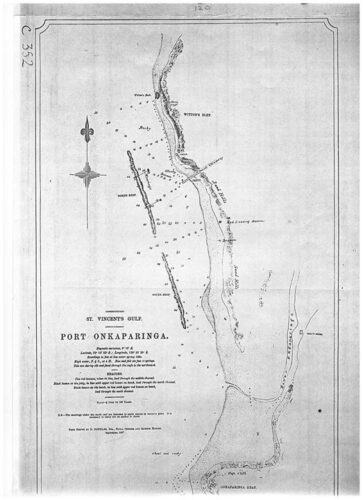
The 1857 plan indicating two mooring chains laid out from the north reef to assist vessels in a westerly gale
The new 1857 plan noted that it would be necessary to carry out an anchor in-shore. It seems that it was the new plan that was actioned, resulting in two sets of chains and three small anchors still laying halfway between the reef and shore.
This version of the same map gives some extra details: –
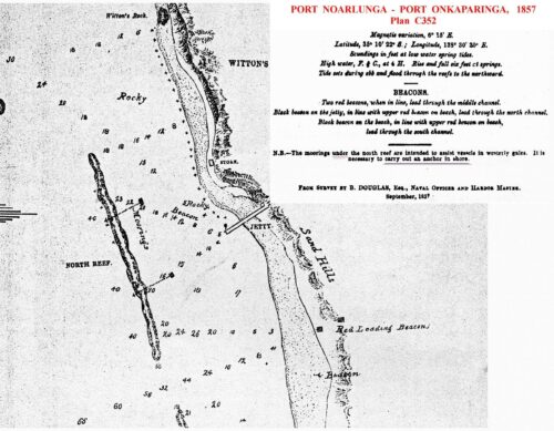
The ‘N.B.’ on this image states “The moorings under the north reef are intended to assist vessels in westerly gales. It is necessary to carry out an anchor in shore.”
The map accompanying this 1856 letter to the Adelaide Observer has been annotated “Anchor in Adamson’s painting” by the northern anchor: –
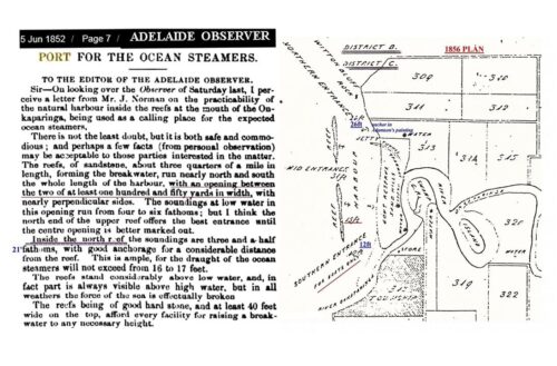
The painting in question is this one by James Hazel Adamson: –

It shows a sailing ship anchored within the reef. Here is a clearer, colour version of the same painting: –

This 1855 painting by James Hazel Adamson shows a ship called the Yatala anchored by the old jetty. It appears then that the moorings were in place by 1855. According to the web page found at http://passengersinhistory.sa.gov.au/node/991044 , a “mooring (had been layed down) at ……. the mouth of the Onkaparinga” in 1853. Port Noarlunga had been known as Port Onkaparinga at the time.
The two-masted Yatala was the Government schooner of the time. Captain Benjamin Germein was the master of the ship from 1854 to 1856 (at least). The 62 to 65-ton wooden top-sail schooner was built by Thomas Scott at Port Adelaide and was launched on 28th July 1848. The ship was damaged at Rivoli Bay and altered to become a fore and aft schooner in 1859. In 1863, it departed with the Beatrice to survey the Northern Territory coast where it ran aground at the Adelaide River and was hulked.
A mooring anchor can be seen on the northern side of the start of the jetty. (Sue Walsh’s great-great-grandfather is also shown (with his gun and spaniel.)
This first jetty at Port Noarlunga was only completed that same year (1855). The present jetty was completed in 1921.
The 30.49m long, 3-masted, wooden barque Duilius was carrying a cargo of wool when it was shipwrecked in Guichen Bay in 1853. According to “South Australian Shipwrecks – A Data Base 1802-1989” by Peter Christopher, the 327-ton barque Duilius struck rock in Guichen Bay, 1-mile south-east of the first jetty built at Robe on 15th April 1853. (At least one source says that it was 5th April.)
It seems that the wreck is located in Guichen Bay, east of the Robe township, north-west of the boat ramp at the end of Steve Woolston Road.
Guichen Bay was named by Louis de Freycinet, the Frenchman who prepared the charts from the Nicolas Baudin expedition of 1800 to 1803. Freycinet’s charts showed the bay as Baie de Guichen. The bay was named in honour of Admiral de Guichen (French navigator Luc Urbain du Bouexic, Comte de Guichen), 1712-1790, who had fought against the English. He had fought against Admiral Lord Rodney (1780), Admiral Hood (1782) and Admiral Howe (1794).
(Baudin had initially called the bay ‘Ance des Albatros’, meaning Albatrosses’ Cove.)
According to “Shipwrecks in South Australia (1836-1875)” by Ronald Parsons, the Duilius was built in England in 1840 (by Swift & Tippett?) and was owned by Codner & Co and registered at Dartmouth. The Duilius was anchored in Guichen Bay loading wool for London on 9th April when a strong north-west gale sprang up and buffeted the ship. The prevailing gale caused the ship to lose two anchors. The wind eventually moderated slightly on the 15th April and Captain W.Maxton took the opportunity to move his ship further from the shore. The anchor broke at the stock when there was a sudden jerk as the cable was being hove in. With no large anchor left, Captain Maxton could only run the ship ashore. It struck a rock and filled with water before settling on the bottom. Captain Maxton abandoned the ship and it became a total loss, although much of the cargo of wool was salvaged and repacked.
According to Christopher Deane in his “South Aussie Snippets” column in the August 2018 issue of Dive Log magazine, her stores, sails, mast and spars, and anchor were salvaged and put up for sale on 23rd June 1853. Chris has now added the following details: –
According to a report in the SA Register on Saturday 25th June 1853 “Samson, Wicksteed and Co. Sold on Thursday on behalf of the owners and underwriters cargo, store, apparel, provisions and furniture from the Dieulius. Other items sold are the bower and steam anchors which sold for three pound and three shillings. Total proceeds from the Dieulius 3,905 pounds 11 shillings and 2 pence.”
Obvious errors are the spelling for the vessel and the reference to a ‘steam’ anchor. It appears that both the bower and the stream anchor were sold together for a total of £3. 3s. Everything else sold for almost £4,000.
According to “Australian Shipwrecks Vol.2, 1851-1871” by Jack Loney, the Duilius arrived at Guichen Bay in early April 1853. There were 520 bales of wool onboard, and more wool was taken aboard. A north-west gale caused the ship to pitch heavily. There was apparently only one main anchor onboard, since three other anchors had been lost at other Australian ports.
As reported in “Shipwrecks in South Australia (1836-1875)” by Ronald Parsons, the Duilius was buffeted by a strong north-west gale and the prevailing gale caused the ship to lose two anchors. When Captain W.Maxton took the opportunity to move his ship further from the shore on the 15th April when the wind eventually moderated slightly, the only remaining large anchor broke at the stock as the cable was being hove in. Captain Maxton could only run the ship ashore where it struck a rock and filled with water before settling on the bottom.
Between the details in “Australian Shipwrecks Vol.2, 1851-1871” by Jack Loney and “Shipwrecks in South Australia (1836-1875)” by Ronald Parsons, there are tales of up to a total of six anchors being lost from the Duilius – three in Guichen Bay and three in other Australian Ports.
Although there is no certainty that the large anchor at Port Noarlunga came from the Duilius, there were possibly three anchors in Guichen Bay available for salvage, and three more anchors that were said to have been lost in other Australian ports. So, there were at least three, and possibly six, anchors from the Duilius available at that time.
According to the web page found at https://dmzapp17p.ris.environment.gov.au/shipwreck/public/wreck/wreck.do?key=5295&action=expandAll , the wreck site for the Duilius “comprises of some timber remains (possibly the keelson) and some frames and planking (with sheathing). Copper bolts, iron knees, an iron hatch are spread out on the site. It is some integrity in that it points in a 330-150 degree orientation and you can follow material along this axis. …… The main feature is a large pile of ballast 1-2 metres high, 10 metres in length by 5m wide. There could be some chain and possibly an anchor lying within it and next to it.”
It seems that the Duilius was named after the Roman admiral Gaius Duilius.
The fellmongery business at Robe may have been prompted by successful attempts to salvage the wool cargo from the Duilius wreck. The ship was the one chartered to take wool direct from Guichen Bay. The ship’s crew managed to land 183 bales of her cargo, but 352 bales remained submerged in seawater in the hold. (That’s 15 more than 520!) Some of the salvaged wool bales were taken to the lake to have the salt washed out of the wool. When that wool was sold back in England, it fetched a higher price than normal. Local wool exporters subsequently decided to wash wool in the lake and fellmongery works were established on the banks of the lake. ‘Fellmongery’ means ‘woolwash’. The lake at Robe is (now?) called Lake Fellmongery. It seems that fellmongering continued at Robe until the 1890s.
(According to Geoffrey Shepherd in The Advertiser of 20th Dec 1947 (https://trove.nla.gov.au/newspaper/article/43749058), when the 800-ton immigrant ship SS Nashwauk was wrecked on 13th May 1855, the ship’s heavy anchor lay 200 yards offshore for 72 years. In 1927, the Noarlunga Council offered £20 to anyone who would recover it. After a struggle, a local resident employing several horse teams managed to haul It In. There were people who thought that the anchor actually belonged to the Tigress, a vessel which was lost earlier on a reef near where the Nashwauk went aground. The indications are that the anchor was from the Nashwauk because it was located near the wreck. If it wasn’t from the Nashwauk, then what happened to the Nashwauk‘s anchor?)

Upon reading my draft for an article about the anchor, Christopher Deane commented, “The anchor size fits the Duilius. I think this perhaps closes the story with 95% <> confidence. “
This article, however, is still a work in progress awaiting more details that may prove or disprove our theory.
My thanks go to both Christopher Deane and Sue Walsh for providing me with the background to the origin of the anchor and a number of maps and newspaper reports.

Nice detective work, Steve, Chris and friends.
[…] Possible origins of the large anchor at Port Noarlunga reef https://mlssa.org.au/2020/03/05/the-large-anchor-at-port-noarlunga-reef-seems-to-have-come-from-the-d… […]