Continuing my recent focus on Witton Bluff, as I wrote in our May 1985 newsletter, it “is situated at the southern end of Christies Beach, just before the northern end of the Port Noarlunga reef. There is a reef at Witton Bluff which extends out to sea from the mainland. It is fully exposed at low tide when it can be walked on.”

I said at the time, “To visit the reef you either have to walk north along the beach from Port Noarlunga at low tide or walk south along a track from Christies Beach. The (then) Noarlunga Council has laid an improved road for pedestrians along the coast from Christies Beach to Port Noarlunga.”
Although I’m not sure about the present situation, at the time I said<“This walkway goes just past the reef at Witton Bluff at present.” As I stated in My Early Diving Days , “Witton Bluff is the high point on the coast between Port Noarlunga and Christies Beach. It is named after the 1839 wreck of the David Witton. I did my ‘first’ sea snorkel there in January 1978.”
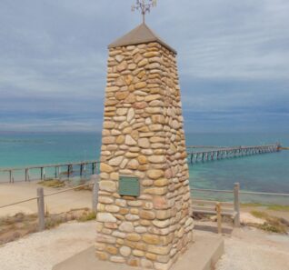
November 2019 marks the 50th anniversary of the raising of the anchor from the David Witton in 1969. As I wrote in 1985, “The David Witton was returning to Port Phillip for a second consignment of sheep for South Australia when a gale blew up and she was wrecked on rocks. It was hoped that the brig could be re-floated but continuing rough seas led to it being auctioned as a total loss. A lot of her gear was saved though, including spars, rigging, timber and sails. Her foremast was used as a semaphore at Glenelg. 30,000 English bricks were also auctioned and were used in the walls of several of the old homes in the Noarlunga district. Some of the material from the David Witton was used to construct the Onkaparinga, a shallow draught vessel which was used on the Onkaparinga River.”
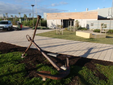
Further, “The building on the Port Noarlunga foreshore is called Witton Centre. An anchor believed to be from the David Witton is located at the centre, along with a plaque which gives details about the brig. It reads: –
“Anchor of the David Witton
This bower anchor, raised from the sea by the Underwater Explorers Club
in November 1969, is believed to be from the brig David Witton, which
ran aground near Witton Bluff during a severe gale on the night of the 14th March* 1839.
After being beached at Port Noarlunga the David Witton was sold at auction, subsequently
rebuilt** and renamed Onkaparinga, and used as a trader between Port Adelaide and the
steam flour mill at Noarlunga. Her flat bottomed construction enabled her to successfully negotiate
the shallow waters of the Onkaparinga River, which she continued to do for some years.”
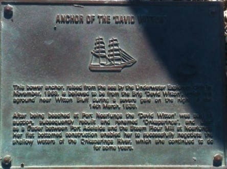
* The date of 14th March 1839 has been reported as March 17th, 18th and even June 1839.
** Only material from the David Witton was used in the construction of the Onkaparinga.
The Onkaparinga was equipped with lee boards and had a carrying capacity of about 20 tons. She began carting materials up the Onkaparinga River for the construction of the Noarlunga steam flour mill late in 1843.
I reported back then that there is a Witton Road just one street back 1839.the Esplanade. Witton Road runs between Beach Road, Christies Beach and Gawler Street, Port Noarlunga.
According to “Shipwrecks in South Australia (1836-1875)” by Ronald Parsons, Captain Arthur Wright was the captain of the David Witton when she was wrecked (“on March 18, 1839”). Parsons says that the David Witton was a 2-masted wooden brig of 271 tons (under the old measurement). She had been built in Monkswearmouthshore, near Sunderland, England in 1833. It was 90′ long, 26’7″ wide and 16’7″ deep.
According to “South Australia – What’s in a Name?” by Rodney Cockburn, the David Witton was 270 tons and was wrecked in June 1839. Cockburn says that the vessel “had landed 1100 ewes at Port Adelaide from the Port Phillip district for Duncan McFarlane, of Mount Barker, and had been chartered for another similar undertaking, when she missed stays in a gale, and was wrecked at the mouth of the Onkaparinga.” He says that the steam flour mill at Noarlunga had been erected by Stephens, Phillips and Dehorne.

According to “Let’s go for a dive” by the Underwater Explorers Club of SA, a “group of UEC divers located an anchor near Pt. Noarlunga reef. The anchor was thought to be off of the wrecked David Witton after which Witton Bluff is named. With the aid of 2 sunken 44 gallon drums attached to the anchor and pumped full of air, it was brought ashore and treated. This anchor is now situated in front of the Pt Noarlunga restaurant together with a plaque acknowledging the UEC’s role.”
[…] David Witton anchor anniversary […]
[…] David Witton brig ran aground in 1838 in the Onkaparinga River, South Australia, we might have found another shipwreck for our […]
[…] wrote in my own article David Witton anchor anniversary , “As I wrote in 1985, “The David Witton was returning to Port Phillip for a second consignment […]
Hello Steve, this is useful historical information about the ship and anchor I am interested to find out more and any references you have to look further into the anchor itself please feel free to email me in this regard regards A. Ward
Thanks Amanda, you have seen https://l.facebook.com/l.php?u=https%3A%2F%2Fstevereynolds.wixsite.com%2Fwebsite%2Fpost%2Fthe-bower-anchor-from-the-david-witton%3Ffbclid%3DIwAR0gEPprz208vyA4FA1vHxQZUbi7-fRSoAZ_Hjf8EoMPU4ESx6t_Nd62eNY&h=AT2FG0ERNACzB9QVkm1GjXQlIp-Y8k1t4gBDji6PJP9aZmicQbNrpgkaIhiWFvT91t9lpvGv0tdaB7PMP0obABKya86P5Y0-jmLfm4vBSJQpi44LA_VCIkbXmxaDXGj7iIdf7AvcSbwd_Fl1mrY by now
I grew up in Pt Noarlunga and as a kid in the 70s. I remember walking the reef, many times, (north from the jetty during lower tides). About 50m along the reef, north from the jetty, we would see a large anchor on the shore side of the reef. Later years, I thought this was the anchor that now sits outside the foreshore restaurant…but it can’t be. I know the David Witton ran ashore further south, at the river mouth…so I wonder what the anchor was that we could see from the reef, north of the jetty?
Hi Brett
A large anchor was located from the north to the south, as explained at https://mlssa.org.au/2020/03/05/the-large-anchor-at-port-noarlunga-reef-seems-to-have-come-from-the-duilius/
Cheers
Steve