Last year, I commenced a private study of the islands of Spencer Gulf, tenuously justified as background research on my forthcoming documentary film, Cuttlefish Country. I was struck by the number and diversity of inshore and offshore islands located there- from the sandy shoals of Curlew Island opposite the power station at Port Augusta in the north, to the rugged granite outcrops of the Neptune Islands beyond the mouth of the Gulf.
Some of these islands were declared conservation parks in their own rights, (Tumby Island, Lipson Island, Bird Islands), some fell within the boundaries of greater National Parks (those within the Lincoln and Innes National parks) while others were partially or wholly privately owned or leased (Louth Island, Thistle Island and others in southern Spencer Gulf).
I believe it is fair to say that the majority of these islands are seldom visited and poorly surveyed- something I hope MLSSA’s membership can remedy in the years ahead.
After disseminating many of my discoveries through creating corresponding Wikipedia pages, my study scope expanded as I searched for islands along Kangaroo Island’s coast. Here I found the Busby and Beatrice Islets and their corresponding conservation parks, Casuarina Islets (also known as The Brothers), Paisley Islet (off the west coast), Pelorus Islet (south east of Cape Gantheaume), Nobby Islet (near Seal Bay) and a number of islands within Pelican Lagoon.
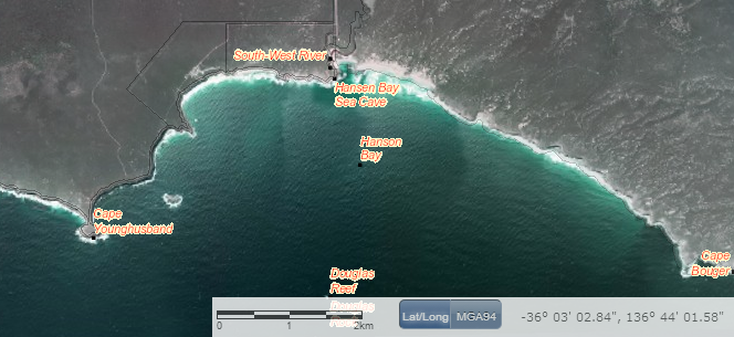
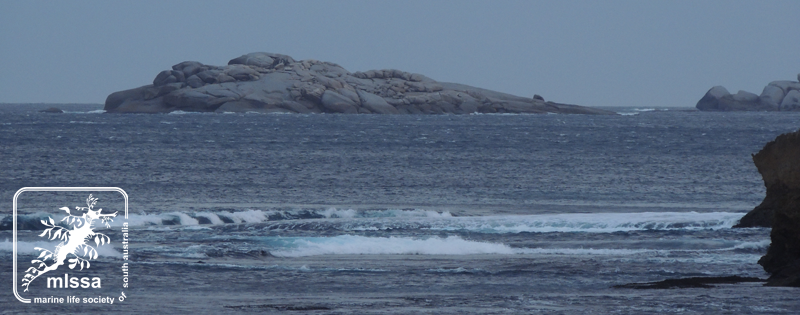
Then, on a recent visit to Kangaroo Island, I sighted from the rocks at Hanson Bay another granite island between Hanson Bay and Cape Younghusband. I am yet to find any map which names this islet, though I’m confident informal names would exist, used by local fishermen. You can see the island at the top of this article.
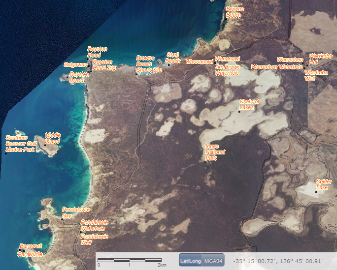
I used several online mapping tools to initially scan the coast for islands, islets and their names. Google Earth was useful initially, but rarely provided names for the smaller islands and islets. Then I discovered the more data rich Property Location Browser courtesy of the SA Government. By switching on the website’s ‘Place names (gazetteer)’ layer I made a surprising revelation. Two of the islands I had noted, including the one I had sighted to the south-west of Hanson Bay, were not formally recorded in the State government’s Gazette.

I obtained the name for the second ungazetted island from a brochure from the Department of the Environment on Innes National Park. It clearly named the three islands located in Pondalowie Bay. These it named (from northernmost to southernmost) somewhat unimaginatively North Island, Middle Island and South Island. In the Gazetteer, South Island was left unnamed, and North Island appeared as Royston Island, with no mention of North Island as an alternative name.

Evidently, some limited biodiversity studies have been made of SA’s offshore islands, as evidenced by this report from 1996. It collates data from surveys conducted between 1971 and 1982… but eighteen years after publication, what has transpired since? It is also unclear if these studies included intertidal and subtidal surveys.
What surprises lie waiting for MLSSA members to discover in the waters around these islands?
I have sent follow-up emails to several people and organisations on Kangaroo Island in the hopes of determining the name for the Hanson Bay/Cape Younghusband islet, and preparing a case for having it gazetted… along with South Island in Pondalowie Bay. Considering South Australia has over 150 offshore islands in total, the west coast of Eyre Peninsula, the Great Australian Bight and South East regions remain to be scanned by any other interested satellite island hoppers and are bound to yield many more surprises.


its called Douglas Rock according to DEWNR maps
Ranger Kangaroo Island
Thanks Anthony- but the rocks/reef associated with that name appear to be much further offshore, as seen in the screen grab from the Government ‘Property Location Browser’ above. These names are drawn from publications of the Government Gazette.
This is a great start to inform ourselves about the incredible marine and island diversity along our magnificent coast. We are still ‘newcomers’ to this ancient land and sea. Anticipating manyMLSSA expeditions in the future to explore some of these islands. I remember visiting several by boat from Coffin Bay as a child – going out as far as ‘The Brothers’ in a cabin inboard boat. They were all swarming with birdlife.
The study of geographic names is known as toponymy. In a 2010 posting on the University of California, Santa Barbara, geology department’s website, Prof. Dan Montello wrote, “In a sense, naming expresses ownership, because it implies both comprehension and the legitimacy of the name’s historical and cultural legacy.” Some geographic names don’t just tell us where we live or where we’re going. They’re a political statement or, in the eyes of some, a politically incorrect one. (Ken Moritsugu, Tokyo)
With that thought in mind, Steve- wouldn’t it be nice to make a visit as MLSSA, survey the island’s sub and intertidal zones, then present a case for naming the island, based on its ecology? That would be a political statement- that the island belongs to the lifeforms which inhabit it.
The State Govt.’s Department of Planning, Transport and Infrastructure is the department responsible for the names of locations in SA. Michael Burdett is the current Surveyor-General of the department. A notice of intention to alter the name of a place (DPTI.2013/16636/01 DATED 11/8/2014) was published in the 14th August issue of The Advertiser. Notice was being given, seeking public comment on a proposal “to create the locality of WEDGE ISLAND to that island known as Wedge Island….” Copies of the plan can be viewed at http://www.sa.gov.au/landservices/namingproposals . Submissions were open for just 1 month from the date of the publication of the notice (14/8?).