Spearfishing
There is a spearfishing restriction at “Second Valley Bay”. It has been in place for over 23 years now. The restriction is listed in the “South Australian Recreational Fishing Guide” under “General Fishing Information/Fish Spear/Hand Spear/Powerheads”. It is also listed at http://pir.sa.gov.au/fishing/fishing_gear/permitted_devices .
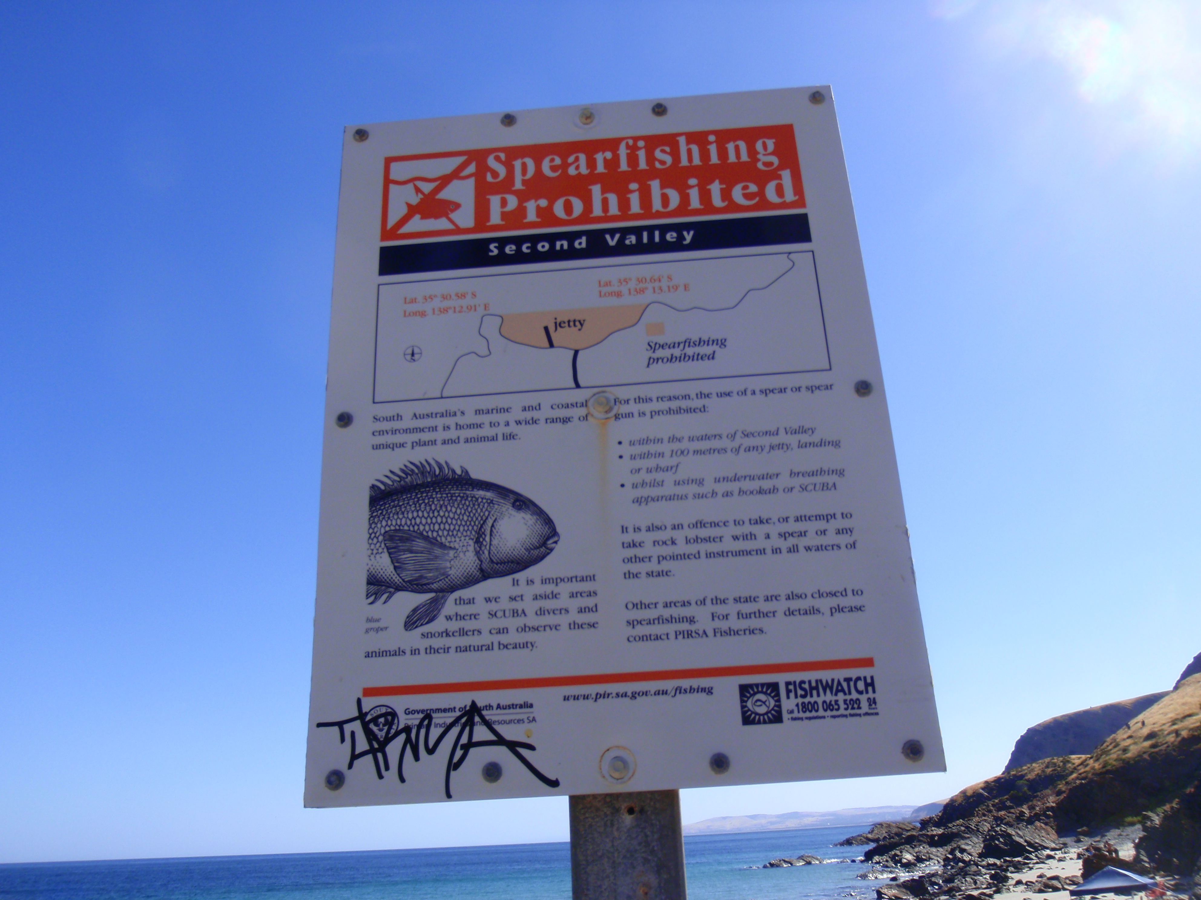
Signage at Second Valley in 2009
(Taken by Steve Reynolds)
As I wrote in my blog , “A spearfishing ban at Second Valley was proclaimed in March 1992. Page 16 of the 2008 (& 2010) “SA Recreational Fishing Guide” says “Spearfishing . . . is not permitted . . . in the waters of Second Valley Bay”.
“As reported in my blog , “A new sign has now been installed at Second Valley, advising of the spearfishing ban in the bay where the jetty is located.” (See details in the photo in my blog. Double click on it to enlarge the image.) So it seems that the ban does not apply to all of Second Valley, only the first bay there. Spearing is apparently allowed in the second bay and beyond. It also seems that spearing would be allowed at Lasseter’s Reef if it is outside of the line between the two points either side of the jetty. Now it may well be that “the waters of Second Valley Bay” only ever meant the first bay. I believe that the second bay and Lasseter’s Reef ought to be included in the banned area. Even then, spearing would still be allowed along the edge of the two points. Perhaps that whole section of coast ought to be included in the ban. Any marine life there needs to be protected for the enjoyment of divers and snorkellers. As it stands at present, policing the current ban would be difficult. Spearfishers may enter or exit the 1st bay but be able to say that they only speared outside of the bay.”
Shark fishing
There are also metropolitan shark fishing restrictions in force. The metropolitan shark fishing restrictions prohibit:
• the use of wire trace or a monofilament trace exceeding 1mm in diameter
• hooks with a shank length greater than 56mm and a gape greater than 23mm.
Restrictions apply:
• between 5am and 9pm daily
• from the southernmost breakwater at Outer Harbor to Yankalilla Bay.
•
Unfortunately, Second Valley and Rapid Bay are just outside of the southernmost boundary for the shark fishing restrictions (Lady Bay at Normanville). With that in mind, MLSSA sent a letter to Leon Bignell, the SA Fisheries Minister in January 2015:
“Dear Sir/Madam
The Marine Life Society of SA believes that the legislation under the Fisheries Management (General) Regulations 2007 prohibiting targeted shark fishing from metropolitan jetties and beaches doesn’t go far enough regarding community concerns about swimmer safety.
Both Second Valley and Rapid Bay are just outside of the southernmost boundary for the shark fishing restrictions (Lady Bay at Normanville).
Second Valley beach is one of the most popular beaches in SA. The bay there is very popular with families for kayaking, snorkelling & diving. Rapid Bay is similarly popular.
We have photographic evidence of a 2m-long dead bronze whaler shark being left on rocks at Second Valley during the January holidays.
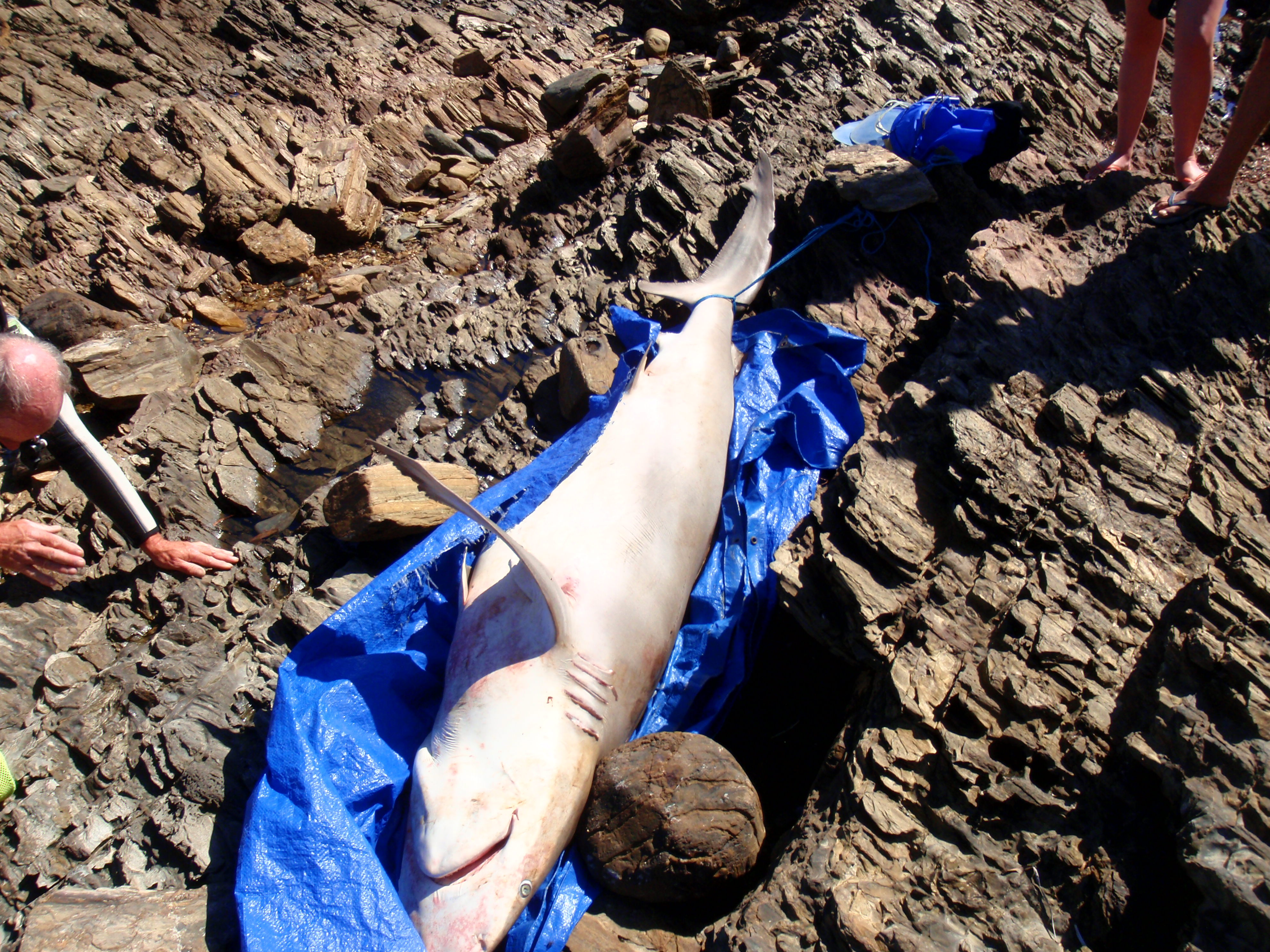
2m-long dead bronze whaler shark left on rocks at Second Valley
(Taken by Steve Reynolds in January 2015)
It seems that a fisherman had left the shark on a tarpaulin and tied it to rocks. The shark would have been in the water at high tide. It probably would have attracted more sharks to the area.
Fishing for sharks at both Second Valley & Rapid Bay has an adverse effect on beachgoers and is of some concern regarding the safety of swimmers.
We therefore ask if the restricted area for daytime shark fishing can be extended to Rapid Head.
Yours sincerely, Steve Reynolds, President, MLSSA”
Mr Bignell’s reply to our letter was as follows:
“Dear Mr Reynolds
Thank you for your recent email requesting an extension to the prohibited area for shark fishing from the Lady Bay shacks to Rapid Head.
Following public concerns about shark fishing from metropolitan waters, and after extensive consultation with local government, coastal organisations, the Fisheries Council of South Australia, shark behavioural experts and RecFishSA, I understand the “Fisheries Management (General) Regulations 2007” were amended in 2013. The amendments prohibit the use of wire trace, thick monofilament trace and large fish hooks to take fish from 5:00am until 9:00pm between the southern Outer Harbor breakwater and the Lady Bay shacks, 4km south of the Normanville jetty.
These arrangements aim to strike a balance between recreational fishing and the interaction with other beach activities. Existing regulations in place prohibit the use of blood, bone, meat, offal or skin of an animal as berley within two nautical miles of the mainland, or any island, or reef, exposed at low water mark. It is also illegal to take fish using fishing gear consisting of a wire trace of 2mm in conjunction with size 12/0 or greater fishing hooks in all state waters at any time.
With the exception of the one bronze whaler shark recently found on the rocks at Second Valley, there does not appear to be any evidence suggesting an increase in shark fishing in the waters from the Lady Bay shacks to Rapid Head in the past two years. The Department of Primary Industries and Regions SA (PIRSA) has not received any reports of illegal berleying in this area in recent times. Accordingly, an extension to the prohibition area to Rapid Head is not considered necessary by PIRSA at this time. If you have any additional information to support an increase (?) in shark fishing in the zone beyond Lady Bay please contact PIRSA.
If you notice someone using blood, bone, meat, offal or skin of an animal as berley, I urge you to report this illegal fishing activity to Fishwatch on telephone 1800 065 522, or via the South Australian Recreational Fishing Guide smartphone app available for free download.
If you have any further questions on this matter, please contact Dr Lianos Triantafillos, PIRSA Fisheries Manager on telephone (08) 8226 2065 or via email (at) lianos.triantafillos@sa.gov.au .
Thank you for writing to me on this matter.
Yours sincerely, Leon Bignell MP, Minister for Agriculture, Food and Fisheries”
We certainly weren’t looking to support an increase in shark fishing in the zone beyond Lady Bay! Remember, if you do notice someone using blood, bone, meat, offal or skin of an animal as berley within two nautical miles of the mainland, or any island, or reef, exposed at low water mark, either report it to Fishwatch (1800 065 522) or via the South Australian Recreational Fishing Guide smartphone app.
Ditto if you see someone using fishing gear consisting of a wire trace of 2mm in conjunction with size 12/0 or greater fishing hooks in all state waters at any time.
Ditto if you see someone using wire trace, thick monofilament trace and large fish hooks to take fish from 5:00am until 9:00pm between the southern Outer Harbor breakwater and the Lady Bay shacks (4km south of the Normanville jetty).
The Goods Shed & the sun shelter
I reproduced this image of the Second Valley causeway in our 2011 & 2012 Journals, courtesy of the State Library of South Australia. It is image PRG 280/1/43/472: –
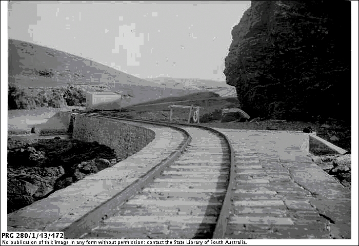
Part of the jetty at Second Valley ca. 1905
(providing a close view of its surface and rail track)
(Image courtesy of the State Library of South Australia PRG 280/1/43/472)
(Now said to be image PRG 280/1/5/430, 1911)
(Source: http://images.slsa.sa.gov.au/searcy/43/PRG280_1_43_472.htm )
Part of the Searcy Collection
It shows the rail tracks running from the car park area to the jetty.
In 2011, I was quite interested in the large shed in the above photograph. It was apparently situated between the car park and the cutting (to allow the flow of the Parananacooka River through the causeway).
I was also interested in these couple of stumps that I found between the river and the start of the jetty, about that time (2011).
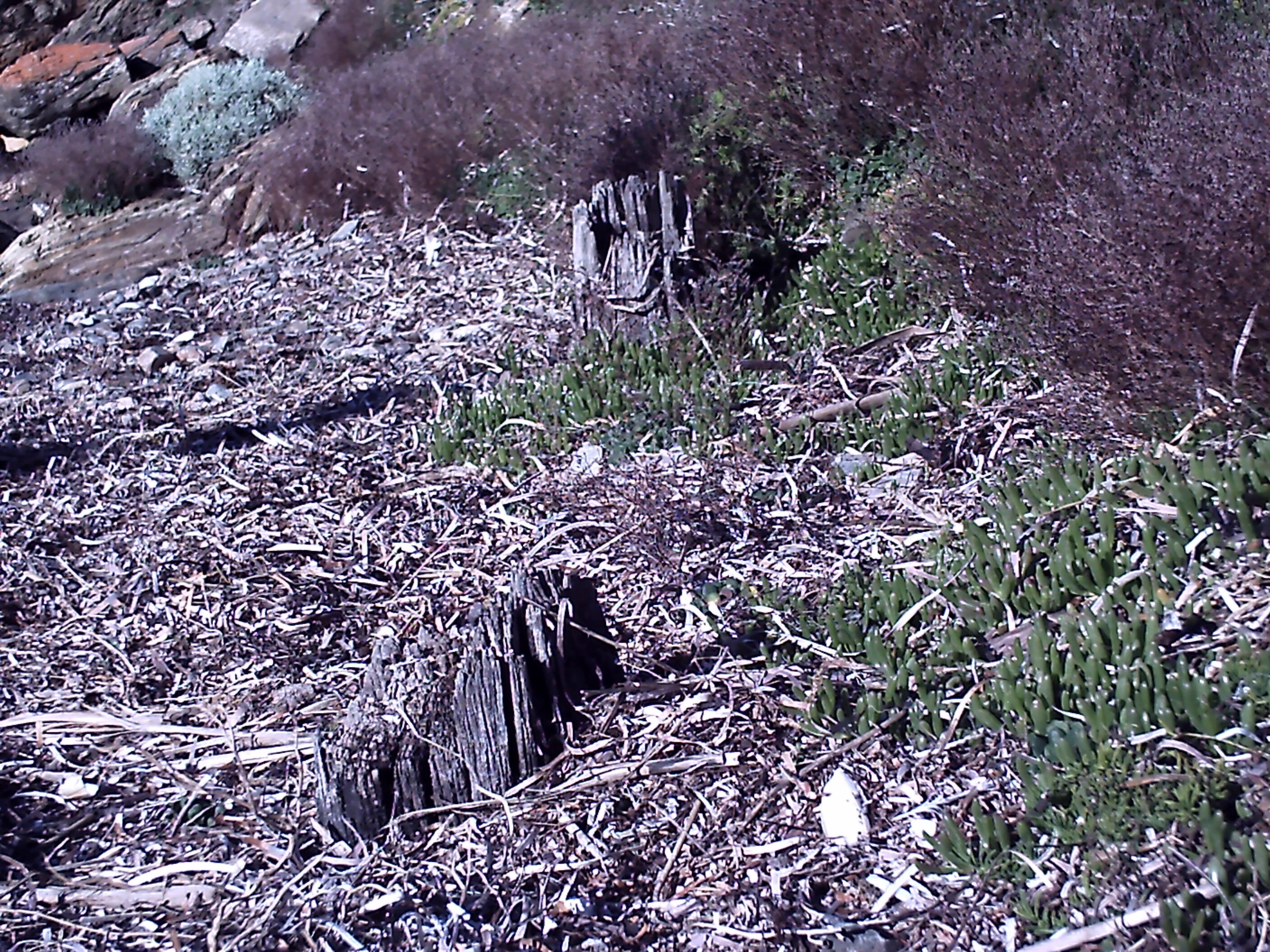
The two stumps found between the river and the start of the jetty
(Taken by Steve Reynolds)
This year (2015), I was able to purchase a copy of Ron Blum’s book titled “Second Valley – Sawmills, Holidays and Boat Sheds” from the Second Valley Jetty Store* (kiosk). The book provided me with a good deal of information regarding Second Valley, including the large shed and a clue as to the origins of the two stumps.
* (See http://www.svcp.com.au/ and https://www.facebook.com/secondvalleycaravanparkjettystore?fref=ts .
Jo and Gregory Woods became the new managers of the Second Valley Caravan Park and Jetty Store on 1st May 2014. They also sell copies of the second edition of Ron Blum’s History of Second Valley book.)
A photo on page 2 of Ron’s book shows the large shed as being located at the corner where the car park meets the causeway to the jetty. It was taken in 1934. The caption accompanying the photo says that the building is a goods shed for the housing of items for shipment. There is a small toilet block close to the shed. Photos of the goods shed also appear on pages 19, 22, 23, 30 & 31 of the book.
As for the two stumps found between the river and the start of the jetty, one of the photos on page 23 of Ron’s book shows three boats adjacent to a shelter located in the vicinity of the stumps. This photo was taken about 1935. It would appear that the two stumps are remains from the old shelter.
There is another photo of the shelter at the bottom of page 23 in the book. This photo was taken in 1954. The caption for the photo suggests that the shelter is simply a sun shelter. It also features in a photo on page 31 of the book, taken in 1937 this time. The goods shed had, however, disappeared in the 1954 photo on page 23.
We can verify from the above-mentioned photos that the goods shed was there at least from 1904 to 1937 and the sun shelter from at least 1935 to 1954.
Poole’s Flat
My 2011 Journal article “The Various ‘Jetties’ at Second Valley” discussed the wooden cutter O.G. which was driven on to rocks at Second Valley in May 1954. She apparently struck rocks at Poole’s Flat, which was an unknown location to me. I have now discovered that Poole’s Flat is said to be Wirrina, and it is said to be located 1½ miles south of Little Gorge and about 2½ miles north of Second Valley jetty (in the old measure).
According to page 31 of Ron’s book, Poole’s Flat was “named after a local landholder who owned three 80 acre Sections”. According to Local Stories from Yarnauwingga to Wirrina Cove, Yarnauwi farm was in the area now occupied by the ‘Wirrina Cove Holiday Park’. “As historical records describe, this area has been an important gathering place for millennia.”
The page goes on to say, “Yarnauwingga, Poole’s Flat and Wirrina Cove: the neighbourhood of the farm – ‘Rapid Recollections’, a recount of early days of settlement on the southwestern Fleurieu from the “Adelaide Register”, alludes to the area of the farm, also sometimes referred to as Poole’s Flat, as the Third Valley.”
It then goes on to say, “Panacooca is the native name for Second Valley. At the head of the valley are two marble hills, one on each side, and at the foot of each hill is a beautiful spring of fresh water. North of Second Valley is Third Valley, which was a great resort for picnic parties in the early days. Bullock drays were the method of conveyance to these gatherings. To the left side of the creek, facing the sea, is what was known [as] Cutter Flat, where the cutter O.G. (the first vessel to be built in the colony) was wrecked in the early fifties. About quarter of a mile inland from this opening is a place known as Pool’s Flat (sic). This was formerly a great meeting place of the blacks, where many battles were fought, and was named by them, Yarnowinga (24 September 1924, p. 12).”
And also, “In 1929, Miss L. Webb added to the recollections of early Rapid Bay and districts describing the indigenous name for the place as Yarnoninga, now understood to be Yarnauwingga. Webb goes on to detail how to “the north of Pool’s Flat (sic), along the beach, is a fair-sized cave, and between that and the Little Gorge is a hidden spring of fresh water” (The Register, 2 February 1928, p. 7). These historic details re-occur, with slight variations, in newspaper recollections throughout the early 20th Century. One account, documented by “A Native of Rapid Bay” describes a gathering of Aboriginal men at Poole’s Flat.”
It then goes on to say, “Coastal trading and the O.G. – Advertisements for livestock in the “South Australian” indicate that the coast adjacent to Poole’s Flat may have had its own jetty at one point (16 February 1847, p. 3) to provide access to the mosquito fleet that serviced the ports of South Australia’s gulfs. The cutter boat O.G., a member the early ‘Mosquito Fleet’ of small trading ships that plied settlements along the coast of South Australia, ended its career wrecked on the rocks at Poole’s Flat. Funded by the South Australia Company, and named in honour of Colonial Treasurer Osmond Gilles, the O.G. was built on the banks of the Patawalonga Creek in 1840. As the first ship built in the colony, it was launched with great fanfare and operated out of Holdfast Bay throughout its working life. While primarily engaged in the fish and oyster trade, “she was a good sea boat and very useful”, also occasionally making “trading voyages with salt and flour cargoes” (Shefi 2006, p. 128). Of the wreck, the Sydney Empire reported that, “This cutter, which left Port Adelaide on the 19th May, for Yankalilla and Rapid Bay, is now a total wreck on Poole’s Flat, about a mile and a half north of the second valley, Rapid Bay. Captain Reid reports that after he had weighed anchor at Yankalilla, at one o’clock in the evening on the 23rd, the wind began to blow hard and increased to a heavy gale. The cutter was very light, having discharged nearly all her cargo, and Captain Reid, finding it impossible to prevent her from driving her ashore, let go his anchor as a last resource. The cutter, however, immediately dragged anchor, and soon struck on the rocks. The crew, consisting of the master, two men, and a boy, saved their lives with great difficulty, by taking to the boat and running her up a creek, but it was a very narrow escape. The burthen of the cutter was only twenty tons, and therefore she was under the size for insurance, so that Captain Reid’s loss by this unfortunate wreck is estimated at above £300. (12 June 1854, p. 3).”
“The writer noted that Poole’s Flat is located “one and a half miles from the Little Gorge, and about two and a half miles from Second Valley jetty” (p. 8). This location corresponds with Ron Blum’s locating of Yarnauwingga/Poole’s Flat at present-day Wirrina Cove in his history ‘The Second Valley”, a location that has been further confirmed through correspondence with local researchers.”
The new jetty steps
My 2012 Journal article titled “The Changing Face of Second Valley Jetty” featured this January 2012 photo of some new steps built at the jetty: –
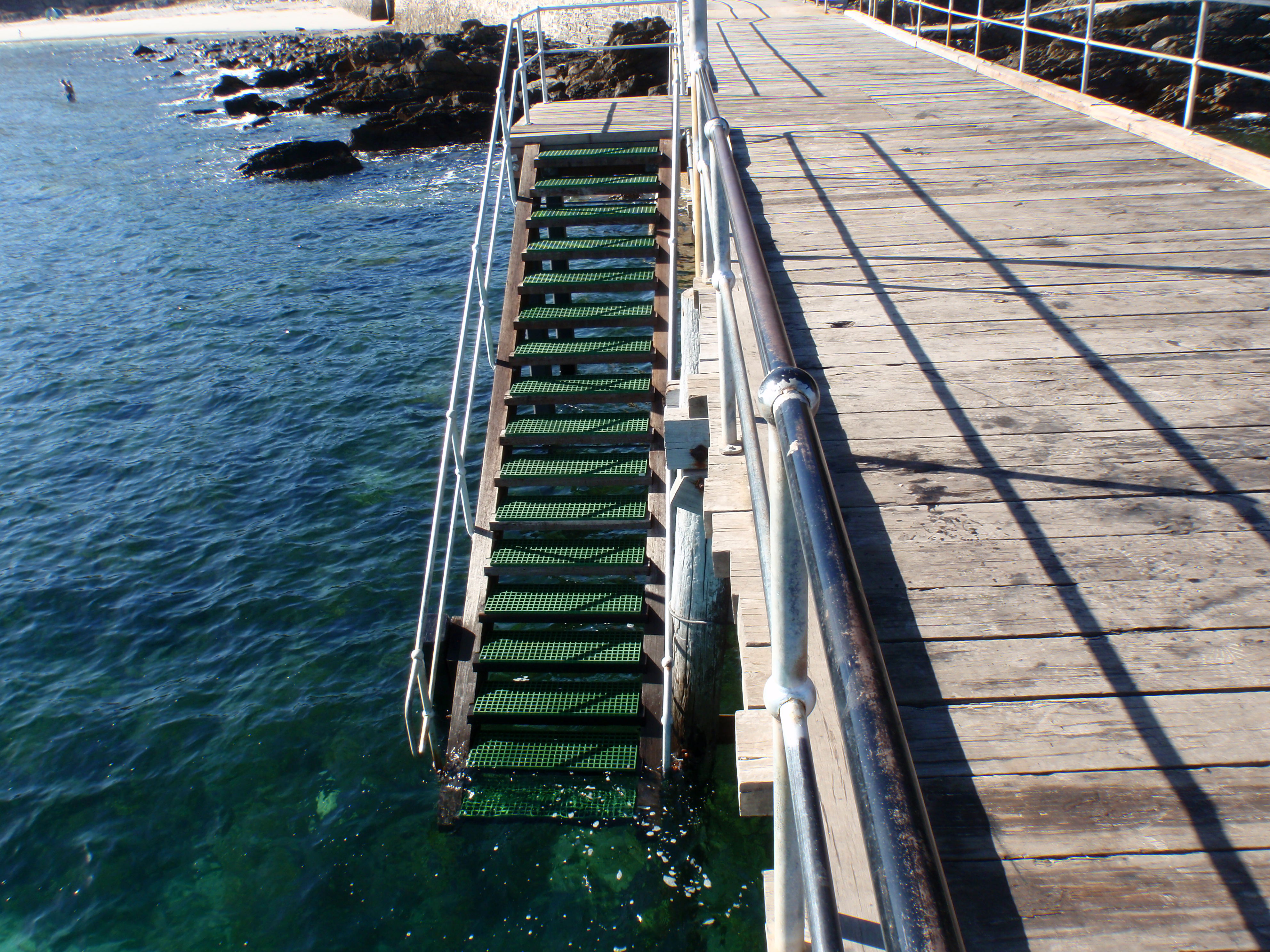
The new steps that were built at Second Valley jetty
(Taken January 2012 by Steve Reynolds)
The ‘temporary’ new ladder
The Second Valley jetty is heritage listed and only ‘heritage type’ materials can be used on the jetty. My 2011 Journal article “The Various ‘Jetties’ at Second Valley” mentioned that once some new steps have been rebuilt, the ‘temporary’ new ladder may be removed to maintain the heritage structure of the jetty. At the time of writing (July 2015), however, the ‘temporary’ new ladder is still there.
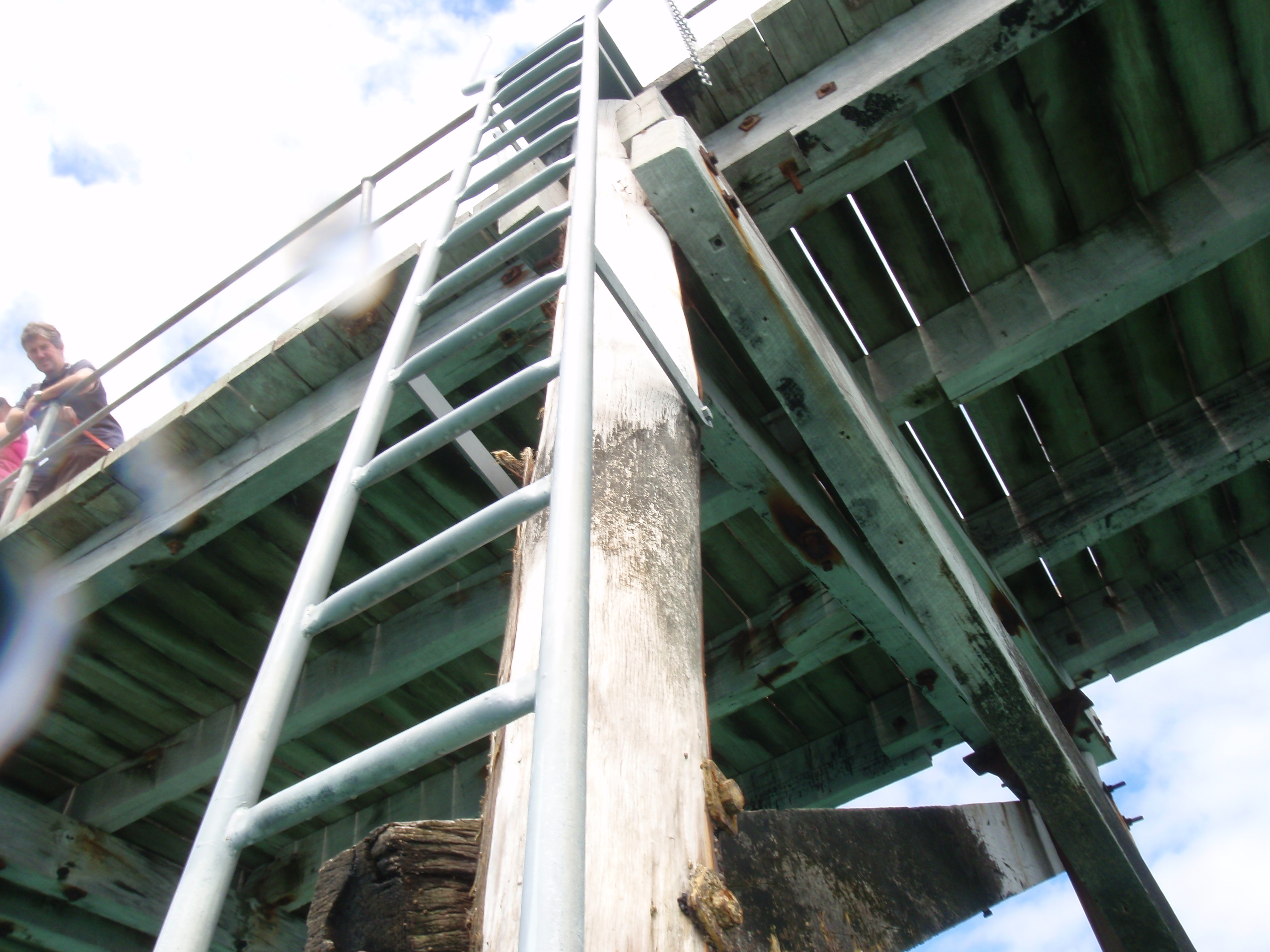
My view of the new ladder from the water
(Taken by Steve Reynolds, with water on lens)
That’s about all for now. I took this photo of Second Valley jetty in February 2013: –
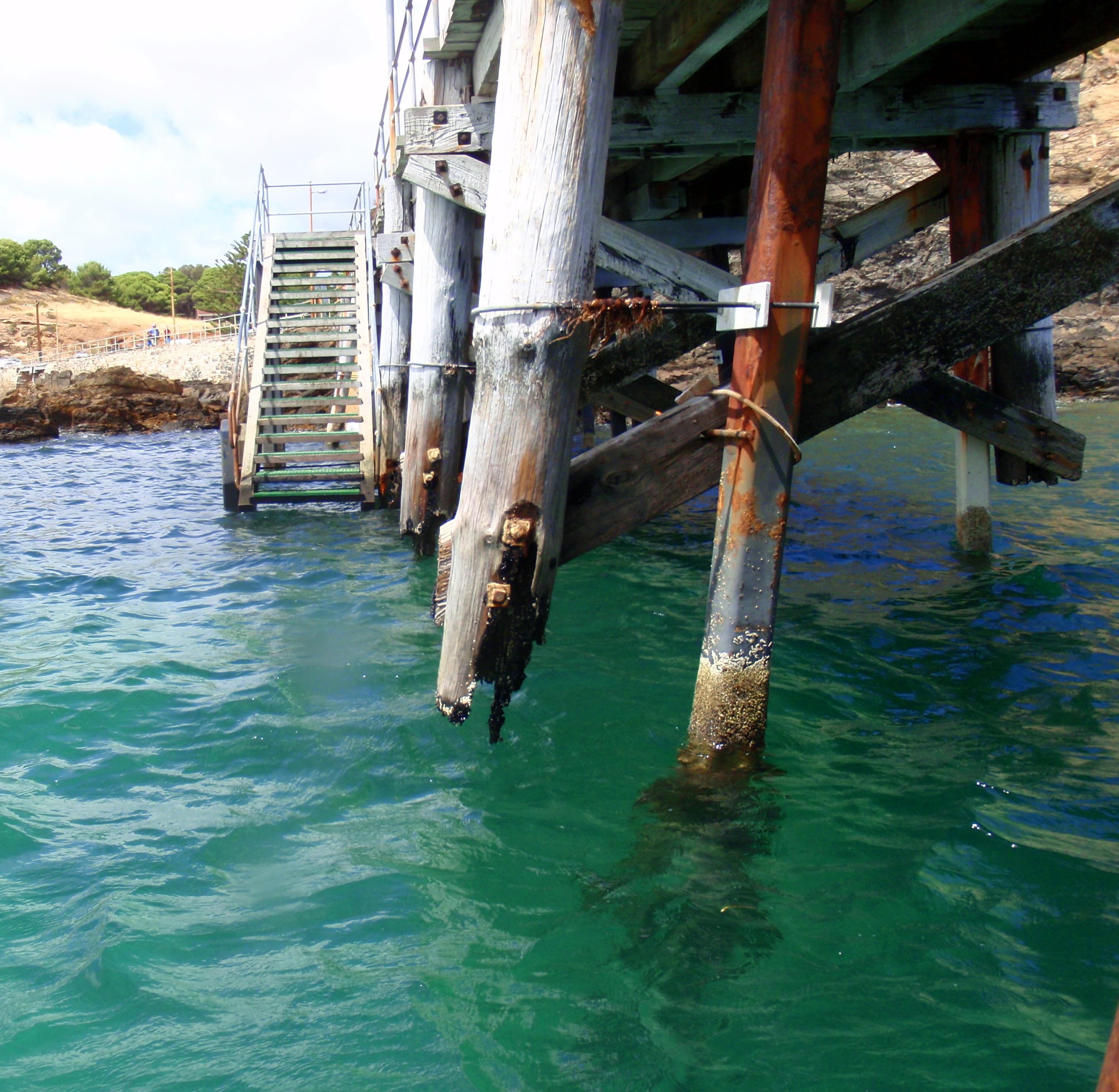
Second Valley jetty in February 2013
(Taken by Steve Reynolds)
Society member Cher McGrath says, “I grew up at Second Valley & we used to walk around to Poole’s Flat very often (in the 60s), or take a boat around there. Before Wirrina was built, Poole’s Flat was a gorgeous beach & there was a bit of surf occasionally. And usually there were lots of dolphins fooling around in the surf. We also found caves above the water line, & had heard stories about old burial sites in the area. My sister & I paddle around there now & still see lots of dolphins.
Good work steve. I could help to implement a full ban on spear fishing at Second Valley. Des Gubbin
Now that’s what I needed to hear! What do you have in mind Des?
David Muirhead knows Des Gubbin well and so I,being that same David and in my current role as Secretary of MLSSA, now take the liberty of saying (on behalf of Des but without having sought his permission !…apologies Des!!) :
I’m very aware that he and his equally pro conservationist spouse, who live in my local council area, have been very, very busy with multiple mostly local projects (catchment care, beach erosion, indigenous site recognition to name a few ).
So you Des understandably may need more time to respond to Steve ‘s latest question but I’m with you on that spearfishing issue so if possible please include me in future discussion by email or phone.
I can probably help in several ways.
Cheers
David Muirhead
Thank you David for you support on a spear fishing ban at Second Valley. I am also would like to see protection given to the Little Gorge Beach as the Yankalilla Council has just recinded the non development status by which would have seen the boat shed and shack removed and the beach returned to its natual state. I must add that 4 councilors voted to reinstate the non development status at the last meeting but the motion was lost. The Lttle Gorge Beach is a place of aboriginal significance as it contains the hidden spring and the Kongeratie Cave. It is also part of the Place of Fallen Bits where Tjirbrukie’s body started to break, you can see this in the cliffs and the large rocks on the shore line and is also part of the Tjilbruke Dreaming story/songline line along the coast of the Fleurieu Peninsula.
Des Gubbin 0417 284 809
Our Society had supported the Second Valley Ratepayers Association plan for a spearfishing ban at Second Valley in 1992